


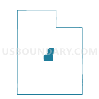
Milburn Voting District, Sanpete County, Utah
About
Outline

Summary
| Unique Area Identifier | 679879 |
| Name | Milburn Voting District |
| County | Sanpete County |
| State | Utah |
| Area (square miles) | 74.16 |
| Land Area (square miles) | 74.16 |
| Water Area (square miles) | 0.00 |
| % of Land Area | 100.00 |
| % of Water Area | 0.00 |
| Latitude of the Internal Point | 39.72100850 |
| Longtitude of the Internal Point | -111.46535940 |
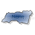
Maps

Graphs
Select a template below for downloading or customizing gragh for Milburn Voting District, Sanpete County, Utah


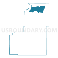
Neighbors
Neighoring Voting District (by Name) Neighboring Voting District on the Map
- Fairview Unincorporated 2 Voting District, Sanpete County, UT
- Fountain Green Unincorporated Voting District, Sanpete County, UT
- Indianola Voting District, Sanpete County, UT
- Nephi 4 Voting District, Juab County, UT
Top 10 Neighboring County Subdivision (by Population) Neighboring County Subdivision on the Map
Top 10 Neighboring Unified School District (by Population) Neighboring Unified School District on the Map
Top 10 Neighboring State Legislative District Lower Chamber (by Population) Neighboring State Legislative District Lower Chamber on the Map
Top 10 Neighboring State Legislative District Upper Chamber (by Population) Neighboring State Legislative District Upper Chamber on the Map
Top 10 Neighboring 111th Congressional District (by Population) Neighboring 111th Congressional District on the Map
Top 10 Neighboring Census Tract (by Population) Neighboring Census Tract on the Map
- Census Tract 9721, Sanpete County, UT (7,630)
- Census Tract 102, Juab County, UT (4,681)
- Census Tract 9722, Sanpete County, UT (3,770)